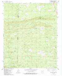
1985 Map of Bog Springs
USGS Topo · Published 1985About this map
Cross Mountains dominate the center of this mid-1980s topographic record, marking the rugged boundary where the Oklahoma Arkansas state line divides Polk and McCurtain counties. The small settlement of Bog Springs serves as a focal point for the surrounding highlands, while Hatton sits near the eastern edge of the survey area. Local religious and community life is anchored by Oak Grove Church, situated among the complex drainages of Cross Creek and West Creek.
Find a feature on this map
24 named features on this map. Tap any name to fly to it.
Don’t see what you’re looking for? This feature index may not catch every label — zoom into the map to look around manually.
Map Details
Editions of this 1985 Bog Springs Map
This is the sole edition of this map. No revisions or reprints were ever made.
Other maps of this area

1902 · Lukfata
USGS Topo · 1:125,000

1913 · De Queen
USGS Topo · 1:125,000

1950 · Mcalester
USGS Topo · 1:250,000

1959 · Cove
USGS Topo · 1:62,500

1959 · Broken Bow
USGS Topo · 1:62,500

1960 · Smithville
USGS Topo · 1:62,500

1962 · McAlester
USGS Topo · 1:250,000

1964 · Gillham
USGS Topo · 1:24,000

1965 · McAlester
USGS Topo · 1:250,000
1966 · De Queen NW
USGS Topo · 1:24,000