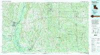
1994 Map of Bogalusa
USGS Topo · Published 1994About this map
The Bogue Chitto River and the Pearl River carve a complex system of bottomlands and islands along the Louisiana-Mississippi border, defining the western portion of this 1994 survey. The industrial center of Bogalusa stands near the edge of the Bogue Chitto National Wildlife Refuge, while the Illinois Central RR corridor anchors settlements like Varnado and Rio. To the east, the landscape transitions into the pine-dominated reaches of the De Soto National Forest.
Find a feature on this map
120 named features on this map. Tap any name to fly to it.
Don’t see what you’re looking for? This feature index may not catch every label — zoom into the map to look around manually.
Map Details
Editions of this 1994 Bogalusa Map
2 editions found
Other maps of this area

1914 · Nicholson
USGS Topo · 1:62,500

1921 · Nicholson
USGS Topo · 1:62,500

1935 · Slidell
USGS Topo · 1:62,500

1935 · Covington
USGS Topo · 1:62,500

1939 · Slidell
USGS Topo · 1:62,500

1939 · Zona
USGS Topo · 1:31,680

1939 · Covington
USGS Topo · 1:62,500

1941 · Honey Island
USGS Topo · 1:31,680

1942 · Waldheim
USGS Topo · 1:31,680

1942 · Thigpen
USGS Topo · 1:31,680