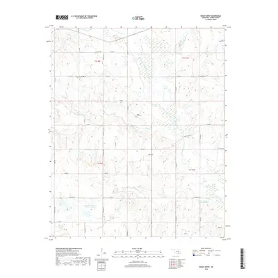
2018 Map of Boggy Depot
USGS Topo · Published 2018About this map
Wilson and Boggy Depot anchor this section of Atoka County, where the landscape is defined by the complex drainage systems of the Clear Boggy Creek and its tributaries. The terrain is marked by significant water management features, including the Lower Clear Boggy Cr Site 10 Reservoir and Lower Clear Boggy Cr Site 6 Reservoir, which reflect mid-to-late 20th-century efforts to control the local hydrology. Genealogists will find substantial value in the documented locations of Wilson Cem, Boggy Depot Cem, and Wards Chapel Cem, which serve as key markers of early family settlement in the region.
Find a feature on this map
54 named features on this map. Tap any name to fly to it.
Don’t see what you’re looking for? This feature index may not catch every label — zoom into the map to look around manually.
Map Details
Editions of this 2018 Boggy Depot Map
This is the sole edition of this map. No revisions or reprints were ever made.
Other maps of this area

1899 · Atoka
USGS Topo · 1:125,000

1900 · Atoka
USGS Topo · 1:125,000

1957 · Lehigh
USGS Topo · 1:24,000

1957 · Ardmore
USGS Topo · 1:250,000

1963 · Ardmore
USGS Topo · 1:250,000
1968 · Wapanucka South
USGS Topo · 1:24,000

1968 · Caddo NW
USGS Topo · 1:24,000
1969 · Boggy Depot
USGS Topo · 1:24,000

1969 · Caddo North
USGS Topo · 1:24,000
1969 · Tushka
USGS Topo · 1:24,000