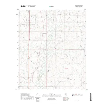
2018 Map of Bogue Chitto
USGS Topo · Published 2018About this map
Bogue Chitto and its neighbor Norfield anchor this section of Lincoln County, where the landscape is defined by the winding course of the Bogue Chitto river and its numerous tributaries. The map details a rural network of small communities and family-named landmarks, including the notable elevation of Blueberry Hill and several historic burial grounds such as Price Cem and Missionary Cem. The settlement pattern follows the established north-south transportation corridor, with clear delineations of townships t6n r7e, t6n r8e, t5n r7e, and t5n r8e. From the northern reaches of Thayer to the southern community of Wilkinson, the area's agricultural and rural character is evidenced by the dense web of local roads like Pricedale Dr SE and Hunters Rd SE, and numerous creek systems including Gills Cr, Boone Cr, and Jordan Cr.
Find a feature on this map
89 named features on this map. Tap any name to fly to it.
Don’t see what you’re looking for? This feature index may not catch every label — zoom into the map to look around manually.
Map Details
Editions of this 2018 Bogue Chitto Map
This is the sole edition of this map. No revisions or reprints were ever made.
Other maps of this area

1953 · Natchez
USGS Topo · 1:250,000

1956 · Natchez
USGS Topo · 1:250,000

1959 · Natchez
USGS Topo · 1:250,000

1972 · West Lincoln
USGS Topo · 1:24,000

1972 · Fair Oak Springs
USGS Topo · 1:24,000

1972 · Auburn
USGS Topo · 1:24,000

1972 · Ruth
USGS Topo · 1:24,000

1972 · Pricedale
USGS Topo · 1:24,000

1972 · Bogue Chitto
USGS Topo · 1:24,000

1972 · Brookhaven
USGS Topo · 1:24,000