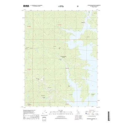
2018 Map of Bohemotash Mountain
USGS Topo · Published 2018About this map
Bohemotash Mountain towers over the deeply incised drainages and complex shoreline of northern California during the late twenty-first century. This portion of the Shasta National Forest is defined by the expansive waters of Shasta Lake, specifically the Sacramento River Arm and Elmore Bay. The terrain is characterized by a series of prominent peaks and ridges, including Mammoth Butte, Jackass Mountain, and Sugarloaf, separated by narrow gulches and canyons. Numerous seasonal and perennial streams like Backbone Creek and Sugarloaf Creek feed into the reservoir system. The presence of Slaughterhouse Island and the proximity of features like Sawmill Gulch and Shoemaker Gulch hint at the historical extractive industries and early land use that preceded the filling of the reservoir. Geographers can observe the intricate intersection of high-relief topography and the engineered shoreline of the lake.
Find a feature on this map
49 named features on this map. Tap any name to fly to it.
Don’t see what you’re looking for? This feature index may not catch every label — zoom into the map to look around manually.
Map Details
Editions of this 2018 Bohemotash Mountain Map
This is the sole edition of this map. No revisions or reprints were ever made.
Other maps of this area

1890 · Red Bluff
USGS Topo · 1:250,000

1894 · Red Bluff
USGS Topo · 1:250,000

1901 · Redding
USGS Topo · 1:125,000

1913 · Weaverville
USGS Topo · 1:125,000

1944 · Redding
USGS Topo · 1:62,500

1944 · French Gulch
USGS Topo · 1:62,500

1946 · Lamoine
USGS Topo · 1:62,500

1946 · Redding
USGS Topo · 1:62,500

1948 · French Gulch
USGS Topo · 1:62,500

1950 · Schell Mtn
USGS Topo · 1:62,500