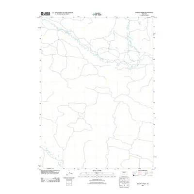
2011 Map of Boiling Spring
USGS Topo · Published 2011About this map
The Calamus River winds across this section of Loup County, defining a landscape of complex riparian braids and oxbow lakes. In this pocket of Nebraska, the river's path is the dominant natural feature, creating a network of wetlands and seasonal water bodies that stand in contrast to the surrounding terrain. Human activity is sparse on the terrain, marked primarily by the inclusion of Co Rd 2-24 and a series of unimproved paths that negotiate the low-lying areas near the riverbanks. This 2011 survey captures the hydrological state of the valley before further environmental or agricultural shifts might alter the fragile water-carved geography of the central Sandhills region.
Find a feature on this map
2 named features on this map. Tap any name to fly to it.
Don’t see what you’re looking for? This feature index may not catch every label — zoom into the map to look around manually.
Map Details
Editions of this 2011 Boiling Spring Map
This is the sole edition of this map. No revisions or reprints were ever made.
Other maps of this area

1952 · Brewster
USGS Topo · 1:24,000

1952 · Almeria NE
USGS Topo · 1:24,000

1952 · Almeria NW
USGS Topo · 1:24,000

1955 · Broken Bow
USGS Topo · 1:250,000

1955 · O'Neill
USGS Topo · 1:250,000

1956 · Broken Bow
USGS Topo · 1:250,000

1959 · O'Neill
USGS Topo · 1:250,000

1969 · O'Neill
USGS Topo · 1:250,000

1981 · Boiling Spring
USGS Topo · 1:24,000
1981 · Shovel Dot Ranch
USGS Topo · 1:24,000