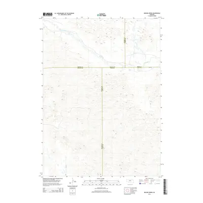
2014 Map of Boiling Spring
USGS Topo · Published 2014About this map
The Calamus River meanders through the northern portion of this quadrangle, creating a ribbon of riparian landscape amidst the complex topographic contours of central Nebraska. This 2014 survey documents a remote intersection of five county lines, where the boundaries of Brown, Rock, Loup, Blaine, and Blaine counties meet. A specific focal point is Boiling Spring, located just south of the river and east of the Loup-Rock county line. The land is largely defined by its natural drainage patterns and the isolated tracks of 846th Rd and Cr-2-24, reflecting a region dominated by ranching and open space rather than dense settlement.
Find a feature on this map
9 named features on this map. Tap any name to fly to it.
Don’t see what you’re looking for? This feature index may not catch every label — zoom into the map to look around manually.
Map Details
Editions of this 2014 Boiling Spring Map
This is the sole edition of this map. No revisions or reprints were ever made.
Other maps of this area

1952 · Brewster
USGS Topo · 1:24,000

1952 · Almeria NE
USGS Topo · 1:24,000

1952 · Almeria NW
USGS Topo · 1:24,000

1955 · Broken Bow
USGS Topo · 1:250,000

1955 · O'Neill
USGS Topo · 1:250,000

1956 · Broken Bow
USGS Topo · 1:250,000

1959 · O'Neill
USGS Topo · 1:250,000

1969 · O'Neill
USGS Topo · 1:250,000

1981 · Boiling Spring
USGS Topo · 1:24,000
1981 · Shovel Dot Ranch
USGS Topo · 1:24,000