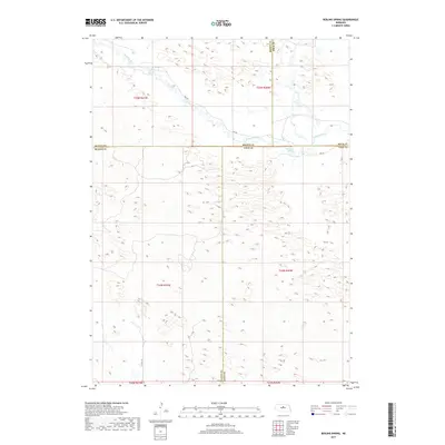
2017 Map of Boiling Spring
USGS Topo · Published 2017About this map
Boiling Spring serves as a distinct hydrological marker in this northern Loup County landscape, where the Calamus River meanders across the Sandhills region. This 2017 survey captures a remote section of Nebraska where the boundaries of Brown, Rock, Blaine, and Loup Counties converge. The terrain is defined by a dense network of sand dunes and depressions, typical of the region's unique topography, with the river providing the primary drainage as it flows eastward. Human infrastructure is limited to rural routes like 846 Rd and Co Rd 2-24, which navigate the township and range lines. The map provides a precise record of the Public Land Survey System divisions, including t24n r20w and t25n r21w, reflecting the enduring grid-based settlement patterns of the American West.
Find a feature on this map
15 named features on this map. Tap any name to fly to it.
Don’t see what you’re looking for? This feature index may not catch every label — zoom into the map to look around manually.
Map Details
Editions of this 2017 Boiling Spring Map
This is the sole edition of this map. No revisions or reprints were ever made.
Other maps of this area

1952 · Brewster
USGS Topo · 1:24,000

1952 · Almeria NE
USGS Topo · 1:24,000

1952 · Almeria NW
USGS Topo · 1:24,000

1955 · Broken Bow
USGS Topo · 1:250,000

1955 · O'Neill
USGS Topo · 1:250,000

1956 · Broken Bow
USGS Topo · 1:250,000

1959 · O'Neill
USGS Topo · 1:250,000

1969 · O'Neill
USGS Topo · 1:250,000

1981 · Boiling Spring
USGS Topo · 1:24,000
1981 · Shovel Dot Ranch
USGS Topo · 1:24,000