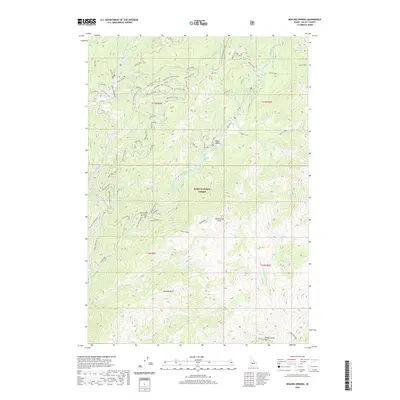
2020 Map of Boiling Springs
USGS Topo · Published 2020About this map
Boiling Springs and the recreation area at Silver Creek Plunge anchor this 2020 map of the remote backcountry within the Boise National Forest. The landscape is defined by the high ridges of Bulldog Ridge and Lightning Ridge, which separate the drainage of the Middle Fork Payette River from the Deadwood River system. This modern survey detail shows a network of forest access roads and spurs, such as Upper Pine Creek and Bryan Creek, weaving through the steep terrain to reach named summits like Trail Creek Summit. The presence of established locations like Peace Valley and Onion Valley suggests the long-standing importance of these high-altitude meadows for both transit and grazing. Local springs, including Lodgepole Springs and Silver Springs, remain critical landmarks in this heavily dissected river valley environment.
Find a feature on this map
59 named features on this map. Tap any name to fly to it.
Don’t see what you’re looking for? This feature index may not catch every label — zoom into the map to look around manually.
Map Details
Editions of this 2020 Boiling Springs Map
This is the sole edition of this map. No revisions or reprints were ever made.
Other maps of this area

1909 · Garden Valley
USGS Topo · 1:125,000

1953 · Boiling Springs
USGS Topo · 1:62,500

1953 · Deadwood Reservoir
USGS Topo · 1:62,500

1957 · Challis
USGS Topo · 1:250,000

1959 · Garden Valley
USGS Topo · 1:62,500

1960 · Challis
USGS Topo · 1:250,000

1963 · Challis
USGS Topo · 1:250,000

1972 · Scott Creek
USGS Topo · 1:24,000

1982 · Deadwood River
USGS Topo · 1:100,000
1988 · Wild Buck Peak
USGS Topo · 1:24,000