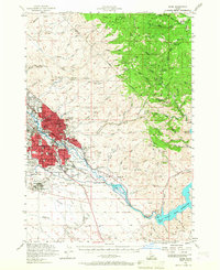
1954 Map of Boise
USGS Topo · Published 1967About this map
Boise and its immediate surroundings are depicted here during a period of significant mid-century expansion, centered on the Boise River valley and extending into the Boise National Forest. The map documents a dense network of local education and social infrastructure, ranging from Boise Jr College and St Marys Sch to the Veterans Hosp and the sprawling State Penitentiary complex. In the highlands to the east, the landscape transitions from urban development to an active mining and ranching district, featuring the Adelmann Mine, Queen Mine, and the Davidson Ranch. The completion of major water management projects is evident with the presence of Lucky Peak Reservoir and the Barber Pond, which fundamentally altered the river corridor near the old Oregon Trail. This survey also captures the city's emerging aviation role at the Boise Air Terminal and the remnants of earlier settlements like Holcomb (Aband).
Find a feature on this map
117 named features on this map. Tap any name to fly to it.
Don’t see what you’re looking for? This feature index may not catch every label — zoom into the map to look around manually.
Map Details
Editions of this 1954 Boise Map
2 editions found

Other maps of this area

1892 · Mountain Home
USGS Topo · 1:125,000

1892 · Boise
USGS Topo · 1:125,000

1892 · Bisuka
USGS Topo · 1:125,000

1893 · Mountain Home
USGS Topo · 1:125,000

1894 · Bisuka
USGS Topo · 1:125,000

1894 · Idaho Basin
USGS Topo · 1:125,000

1897 · Boise
USGS Topo · 1:125,000

1949 · Robie Creek
USGS Topo · 1:24,000

1953 · Eagle
USGS Topo · 1:24,000

1953 · Cloverdale
USGS Topo · 1:24,000