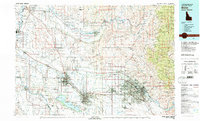
1981 Map of Boise
USGS Topo · Published 1981About this map
The Boise River valley and its surrounding high desert plateaus are meticulously documented in this 1981 survey, capturing the agricultural and urban expansion of the Treasure Valley. The corridor between Boise and Caldwell shows the dense network of irrigation infrastructure essential to the region's growth, including the New York Canal and Phyllis Canal. To the south, the Deer Flat National Wildlife Refuge and Lake Lowell stand as major landmarks, while the Boise Front and Shafer Butte rise to the northeast, marking the transition into the Boise National Forest.
Find a feature on this map
200 named features on this map. Tap any name to fly to it.
Don’t see what you’re looking for? This feature index may not catch every label — zoom into the map to look around manually.
Map Details
Editions of this 1981 Boise Map
2 editions found
Other maps of this area

1892 · Mountain Home
USGS Topo · 1:125,000

1892 · Boise
USGS Topo · 1:125,000

1892 · Bisuka
USGS Topo · 1:125,000

1892 · Silver City
USGS Topo · 1:125,000

1893 · Mountain Home
USGS Topo · 1:125,000

1894 · Bisuka
USGS Topo · 1:125,000

1894 · Silver City
USGS Topo · 1:125,000

1894 · Squaw Creek
USGS Topo · 1:125,000

1894 · Idaho Basin
USGS Topo · 1:125,000

1897 · Boise
USGS Topo · 1:125,000