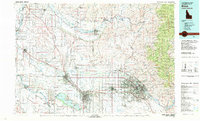
1981 Map of Boise
USGS Topo · Published 1981About this map
The Boise River valley anchors this detailed 1981 survey, documenting the expanding urban footprints of Boise, Meridian, and Nampa during a period of significant growth. The map illustrates a complex hydraulic landscape where the Snake River and Payette River meet an intricate network of irrigation and drainage features like the Dixie Drain and Middleton Slough. To the west, the Deer Flat National Wildlife Refuge surrounds the prominent Lake Lowell, while the northeast is defined by the rising elevations of the Boise Ridge within the Boise National Forest.
Find a feature on this map
126 named features on this map. Tap any name to fly to it.
Don’t see what you’re looking for? This feature index may not catch every label — zoom into the map to look around manually.
Map Details
Editions of this 1981 Boise Map
2 editions found
Other maps of this area

1892 · Mountain Home
USGS Topo · 1:125,000

1892 · Boise
USGS Topo · 1:125,000

1892 · Bisuka
USGS Topo · 1:125,000

1892 · Silver City
USGS Topo · 1:125,000

1893 · Mountain Home
USGS Topo · 1:125,000

1894 · Bisuka
USGS Topo · 1:125,000

1894 · Silver City
USGS Topo · 1:125,000

1894 · Squaw Creek
USGS Topo · 1:125,000

1894 · Idaho Basin
USGS Topo · 1:125,000

1897 · Boise
USGS Topo · 1:125,000