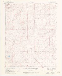
1969 Map of Boise City SE
USGS Topo · Published 1971About this map
Cleveland township defines the central expanse of this high plains landscape at the edge of the Oklahoma Panhandle during the late 1960s. The topography is marked by a rigorous section line grid, with the Oklahoma Texas border forming the definitive southern boundary of the quadrangle. Along this line, the Cimarron Co Dallam Co boundary marks the transition between Oklahoma's Cimarron County and Texas's Dallam County, anchored by the Base Line.
Find a feature on this map
5 named features on this map. Tap any name to fly to it.
Don’t see what you’re looking for? This feature index may not catch every label — zoom into the map to look around manually.
Map Details
Editions of this 1969 Boise City SE Map
2 editions found
Other maps of this area

1954 · Dalhart
USGS Topo · 1:250,000

1958 · Dalhart
USGS Topo · 1:250,000

1962 · Dalhart
USGS Topo · 1:250,000

1969 · Boise City
USGS Topo · 1:24,000

1969 · Boise City NW
USGS Topo · 1:24,000

1969 · Boise City SW
USGS Topo · 1:24,000

1969 · Boise City SE
USGS Topo · 1:24,000

1971 · Conrad NW
USGS Topo · 1:24,000

1971 · Conrad SW
USGS Topo · 1:24,000

1973 · Stratford 2 NW
USGS Topo · 1:24,000