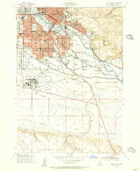
1954 Map of Boise South
USGS Topo · Published 1956About this map
State Capitol and the downtown core of Boise dominate the northern portion of this mid-century survey, revealing a capital city defined by its relationship with the Boise River and an extensive network of irrigation infrastructure. The landscape is crisscrossed by vital waterways including the Ridenbaugh Canal, Settlers Canal, and the large New York Canal, which supported the region's agricultural expansion. To the east, the State Penitentiary sits near the foot of Table Rock, while the southern reaches show the early footprint of the Boise Air Terminal. Educational and civic life is well-documented through numerous neighborhood institutions like South Jr High Sch and Boise Jr College. A notable detail for local historians is the site of Holcomb Sch (Abandoned), marking a shift in the rural educational landscape as the city's residential boundaries pushed outward.
Find a feature on this map
52 named features on this map. Tap any name to fly to it.
Don’t see what you’re looking for? This feature index may not catch every label — zoom into the map to look around manually.
Map Details
Editions of this 1954 Boise South Map
2 editions found
Other maps of this area

1892 · Boise
USGS Topo · 1:125,000

1892 · Bisuka
USGS Topo · 1:125,000

1894 · Bisuka
USGS Topo · 1:125,000

1897 · Boise
USGS Topo · 1:125,000

1949 · Robie Creek
USGS Topo · 1:24,000

1953 · Eagle
USGS Topo · 1:24,000

1953 · Cloverdale
USGS Topo · 1:24,000

1954 · Boise South
USGS Topo · 1:24,000

1954 · Boise North
USGS Topo · 1:24,000

1954 · Boise
USGS Topo · 1:62,500