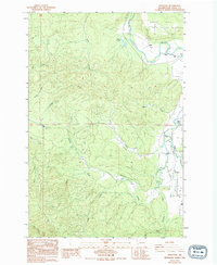
1986 Map of Boistfort
USGS Topo · Published 1994About this map
The South Fork Chehalis River and Chehalis River define the eastern edge of this Lewis County landscape, where the flat river valley meets the rising timberlands to the west. Near the confluence, the small community of Boistfort serves as a local hub, anchored by Boistfort Park and a nearby Cemetery. To the north, the settlement of Ceres sits beneath the prominent Ceres Hill, overlooking the Miller Swamp.
Find a feature on this map
32 named features on this map. Tap any name to fly to it.
Don’t see what you’re looking for? This feature index may not catch every label — zoom into the map to look around manually.
Map Details
Editions of this 1986 Boistfort Map
2 editions found
Other maps of this area

1941 · Walville
USGS Topo · 1:62,500

1941 · Meskill
USGS Topo · 1:62,500

1941 · Skamokawa
USGS Topo · 1:62,500

1953 · Hoquiam
USGS Topo · 1:250,000

1953 · Ryderwood
USGS Topo · 1:62,500

1953 · Skamokawa
USGS Topo · 1:62,500

1953 · Pe Ell
USGS Topo · 1:62,500

1953 · Adna
USGS Topo · 1:62,500

1957 · Hoquiam
USGS Topo · 1:250,000

1958 · Hoquiam
USGS Topo · 1:250,000