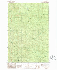
1986 Map of Boistfort Peak
USGS Topo · Published 1986About this map
Boistfort Peak serves as the prominent high point in this 1980s landscape, marking the convergence of Lewis, Wahkiakum, and Cowlitz counties. The area is defined by a dense network of watercourses, with the South Fork Chehalis River and the East Fork Elochoman River draining the higher elevations. Multiple peaks and ridges, such as Ferrier Peak, Sure Shot Mtn, and Clinton Knob, dominate the terrain, illustrating the complex topography of this timber-rich region. Evidence of industrial activity is scattered across the slopes, including several noted Quarry sites and a Borrow Pit near Round Knob. The drainage patterns of Stillman Creek and its various tributaries like West Fork Stillman Creek reveal the natural corridors used for navigation and transport throughout the deep valleys of the coastal range during this era.
Find a feature on this map
28 named features on this map. Tap any name to fly to it.
Don’t see what you’re looking for? This feature index may not catch every label — zoom into the map to look around manually.
Map Details
Editions of this 1986 Boistfort Peak Map
This is the sole edition of this map. No revisions or reprints were ever made.
Other maps of this area

1941 · Walville
USGS Topo · 1:62,500

1941 · Meskill
USGS Topo · 1:62,500

1941 · Skamokawa
USGS Topo · 1:62,500

1953 · Hoquiam
USGS Topo · 1:250,000

1953 · Ryderwood
USGS Topo · 1:62,500

1953 · Skamokawa
USGS Topo · 1:62,500

1953 · Pe Ell
USGS Topo · 1:62,500

1953 · Adna
USGS Topo · 1:62,500

1957 · Hoquiam
USGS Topo · 1:250,000

1958 · Hoquiam
USGS Topo · 1:250,000