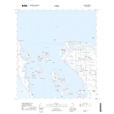
2018 Map of Bokeelia
USGS Topo · Published 2018About this map
Pine Island Sound and the northern reaches of Lee County's coastal islands are documented here with striking precision. The landscape is a complex network of keys and bayous, where the Intracoastal Waterway threads between the mainland and the Gulf barrier. The settlement of Bokeelia serves as a northern anchor, while Pineland sits further south along the shore. Historical and archaeological interest is centered on features like Faulkner Mound and the various named keys such as Cabbage Key and Useppa Island. This environment is shaped by water, from the wide expanse of Charlotte Harbor to smaller inlets like Murdock Bayou and Back Bay. The map details the transition from residential developments near Pine Island Center and the Pine Island Airport to the undeveloped stretches of Cayo Costa, reflecting the area's dual nature as a inhabited coastal community and a preserved natural estuary.
Find a feature on this map
111 named features on this map. Tap any name to fly to it.
Don’t see what you’re looking for? This feature index may not catch every label — zoom into the map to look around manually.
Map Details
Editions of this 2018 Bokeelia Map
This is the sole edition of this map. No revisions or reprints were ever made.
Other maps of this area

1956 · Punta Gorda SE
USGS Topo · 1:24,000

1956 · Tampa
USGS Topo · 1:250,000

1956 · Charlotte Harbor
USGS Topo · 1:250,000

1957 · Punta Gorda SW
USGS Topo · 1:24,000

1957 · Placida
USGS Topo · 1:24,000

1958 · Matlacha
USGS Topo · 1:24,000

1958 · Captiva
USGS Topo · 1:24,000

1958 · Port Boca Grande
USGS Topo · 1:24,000

1958 · Pine Island Center
USGS Topo · 1:24,000

1958 · Bokeelia
USGS Topo · 1:24,000