
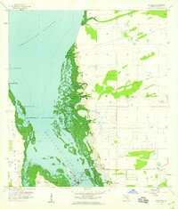
1958 Map of Matlacha
USGS Topo · Published 1958About this map
Matlacha serves as a small coastal hub connecting the larger landmasses of Pine Island and Little Pine Island in this 1958 topographic survey. This coastal environment is defined by an intricate network of mangrove keys and tidal waters, including the expansive Matlacha Pass and Charlotte Harbor. The presence of the Pine Island Bridge and the Pine Island Ch indicates a developing community tied closely to the waterfront economy and transit.
Find a feature on this map
33 named features on this map. Tap any name to fly to it.
Don’t see what you’re looking for? This feature index may not catch every label — zoom into the map to look around manually.
Map Details
Editions of this 1958 Matlacha Map
4 editions found
Other maps of this area

1956 · Punta Gorda SE
USGS Topo · 1:24,000

1956 · West Palm Beach
USGS Topo · 1:250,000

1956 · Tampa
USGS Topo · 1:250,000

1956 · Charlotte Harbor
USGS Topo · 1:250,000

1957 · West Palm Beach
USGS Topo · 1:250,000

1957 · Punta Gorda SW
USGS Topo · 1:24,000

1957 · Gilchrist
USGS Topo · 1:24,000

1958 · West Palm Beach
USGS Topo · 1:250,000

1958 · Captiva
USGS Topo · 1:24,000

1958 · Fort Myers NW
USGS Topo · 1:24,000