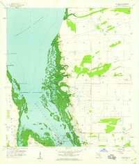
1958 Map of Matlacha
USGS Topo · Published 1959About this map
Matlacha serves as the central hub for this coastal survey, situated where the Pine Island Bridge connects the mainland to the northern reaches of Pine Island. The intricate shoreline of Matlacha Pass is defined by a dense network of mangroves and small keys, including Big Smokehouse Key, Bird Rookery Keys, and the morbidly named Big Dead Key. Further inland, the landscape transitions to the low-lying wetlands of Dead Slough and the engineered drainage of the Gator Slough Canal.
Find a feature on this map
36 named features on this map. Tap any name to fly to it.
Don’t see what you’re looking for? This feature index may not catch every label — zoom into the map to look around manually.
Map Details
Editions of this 1958 Matlacha Map
4 editions found
Other maps of this area

1956 · Punta Gorda SE
USGS Topo · 1:24,000

1956 · West Palm Beach
USGS Topo · 1:250,000

1956 · Tampa
USGS Topo · 1:250,000

1956 · Charlotte Harbor
USGS Topo · 1:250,000

1957 · West Palm Beach
USGS Topo · 1:250,000

1957 · Punta Gorda SW
USGS Topo · 1:24,000

1957 · Gilchrist
USGS Topo · 1:24,000

1958 · West Palm Beach
USGS Topo · 1:250,000

1958 · Matlacha
USGS Topo · 1:24,000

1958 · Captiva
USGS Topo · 1:24,000