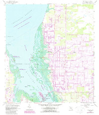
1958 Map of Matlacha
USGS Topo · Published 1987About this map
Matlacha serves as the gateway to the coastal islands in this 1958 survey, updated in the late 1980s to show the dramatic inland expansion of Cape Coral. While the western portion of the map remains a labyrinth of mangrove keys and tidal waters within the Matlacha Pass National Wildlife Refuge, the eastern half reveals an extensive network of planned residential canals. This stark contrast illustrates the era of massive coastal development in Lee County, as dredging transformed the landscape north of Gator Slough. Cultural landmarks like the Pine Island Lookout Tower and the Pine Island Bridge provide specific points of reference for local historians. Navigation through the Matlacha Pass Aquatic Preserve is marked by numerous named features such as Indian Field, Porpoise Point Island, and Big Dead Key, preserving the nomenclature of the Florida Gulf Coast's intricate shoreline.
Find a feature on this map
40 named features on this map. Tap any name to fly to it.
Don’t see what you’re looking for? This feature index may not catch every label — zoom into the map to look around manually.
Map Details
Editions of this 1958 Matlacha Map
4 editions found
Other maps of this area

1956 · Punta Gorda SE
USGS Topo · 1:24,000

1956 · West Palm Beach
USGS Topo · 1:250,000

1956 · Tampa
USGS Topo · 1:250,000

1956 · Charlotte Harbor
USGS Topo · 1:250,000

1957 · West Palm Beach
USGS Topo · 1:250,000

1957 · Punta Gorda SW
USGS Topo · 1:24,000

1957 · Gilchrist
USGS Topo · 1:24,000

1958 · West Palm Beach
USGS Topo · 1:250,000

1958 · Matlacha
USGS Topo · 1:24,000

1958 · Captiva
USGS Topo · 1:24,000