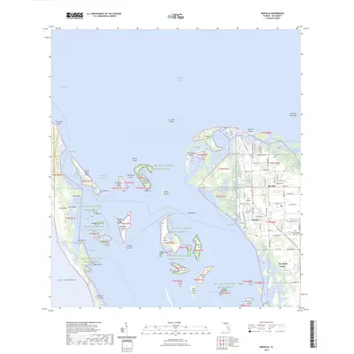
2024 Map of Bokeelia
USGS Topo · Published 2024About this map
Pine Island and its surrounding archipelago define this coastal landscape, where the settlements of Bokeelia and Pineland serve as the primary hubs. The map reveals a complex network of keys and bays within the Pine Island National Wildlife Refuge, including Cabbage Key, Useppa Island, and the barrier beach of Cayo Costa. Local history is anchored by the presence of Howard Mound and Faulkner Mound, indicating the long-standing significance of these elevated sites. The modern character of the area is shaped by its maritime orientation, featuring the Intracoastal Waterway, the Great Calusa Blueway Trail Phase II Trl, and the Florida Circumnavigational Paddling Trl. In the interior, the Pine Island Airport and a grid of local roads like Judge Bean Rd and Pineland Rd connect residential pockets to the shoreline, while numerous shoals and bayous like Jug Creek Shoal and Old Tom Bayou navigate the shallow coastal waters.
Find a feature on this map
95 named features on this map. Tap any name to fly to it.
Don’t see what you’re looking for? This feature index may not catch every label — zoom into the map to look around manually.
Map Details
Editions of this 2024 Bokeelia Map
This is the sole edition of this map. No revisions or reprints were ever made.
Other maps of this area

1956 · Punta Gorda SE
USGS Topo · 1:24,000

1956 · Tampa
USGS Topo · 1:250,000

1956 · Charlotte Harbor
USGS Topo · 1:250,000

1957 · Punta Gorda SW
USGS Topo · 1:24,000

1957 · Placida
USGS Topo · 1:24,000

1958 · Matlacha
USGS Topo · 1:24,000

1958 · Captiva
USGS Topo · 1:24,000

1958 · Port Boca Grande
USGS Topo · 1:24,000

1958 · Pine Island Center
USGS Topo · 1:24,000

1958 · Bokeelia
USGS Topo · 1:24,000