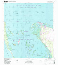
1994 Map of Bokeelia
USGS Topo · Published 1998About this map
Pine Island dominates this coastal survey, where the northern settlements of Bokeelia and Pineland sit amidst a complex network of bayous and keys. The landscape reflects a mix of modern conservation and ancient human activity, evidenced by archaeological sites like Howard Mound, Old Ware Mound, and Faulkner Mound. Navigational features such as Jug Creek and the Wilson Cut highlight the importance of water passage in this environment. Much of the surrounding waters and smaller islands are protected within the State Aquatic Preserve and the Pine Island National Wildlife Refuge, which encompasses land on Cabbage Key and Useppa Island. To the west, the barrier island of Cayo Costa borders the Gulf of Mexico, separated from the main island by the shallow reaches of Pine Island Sound. This map provides a detailed view of the Lee County coast before significant development altered the character of these barrier islands.
Find a feature on this map
56 named features on this map. Tap any name to fly to it.
Don’t see what you’re looking for? This feature index may not catch every label — zoom into the map to look around manually.
Map Details
Editions of this 1994 Bokeelia Map
This is the sole edition of this map. No revisions or reprints were ever made.
Other maps of this area

1956 · Punta Gorda SE
USGS Topo · 1:24,000

1956 · Tampa
USGS Topo · 1:250,000

1956 · Charlotte Harbor
USGS Topo · 1:250,000

1957 · Punta Gorda SW
USGS Topo · 1:24,000

1957 · Placida
USGS Topo · 1:24,000

1958 · Matlacha
USGS Topo · 1:24,000

1958 · Captiva
USGS Topo · 1:24,000

1958 · Port Boca Grande
USGS Topo · 1:24,000

1958 · Pine Island Center
USGS Topo · 1:24,000

1958 · Bokeelia
USGS Topo · 1:24,000