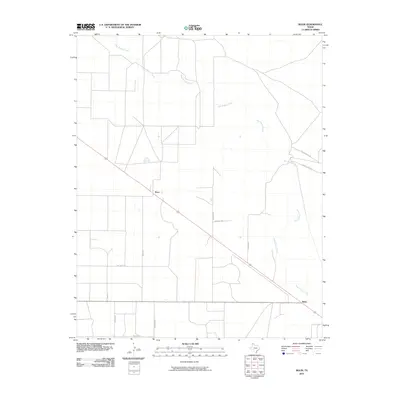
2010 Map of Bolin
USGS Topo · Published 2010About this map
Rita Blanca Creek meanders across this High Plains landscape, anchoring a region of the Texas Panhandle defined by its vast agricultural and ranching layout. In 2010, the small communities of Ware and Bolin serve as the primary hubs for this rural expanse, connected by a rigid grid of local thoroughfares. The road network here often carries the names of local residents or landmarks, such as Brorman Rd, Newman Rd, and Frazier Rd, providing a clear record of land ownership and local travel patterns in Dallam County. A prominent rail line bisects the territory, running northwest to southeast through Ware and Bolin, illustrating the historical dependence of these Panhandle settlements on transportation corridors for cattle and grain transit. Other local markers like Spielman Ln and Mustang Ln further delineate the divided sections of the prairie.
Find a feature on this map
14 named features on this map. Tap any name to fly to it.
Don’t see what you’re looking for? This feature index may not catch every label — zoom into the map to look around manually.
Map Details
Editions of this 2010 Bolin Map
This is the sole edition of this map. No revisions or reprints were ever made.
Other maps of this area

1954 · Dalhart
USGS Topo · 1:250,000

1958 · Dalhart
USGS Topo · 1:250,000

1962 · Dalhart
USGS Topo · 1:250,000

1973 · Wharton Ranch
USGS Topo · 1:24,000

1973 · Tovrea Ranch
USGS Topo · 1:24,000

1973 · Perico
USGS Topo · 1:24,000

1973 · Canyon School
USGS Topo · 1:24,000

1973 · Bolin NE
USGS Topo · 1:24,000

1973 · Bolin
USGS Topo · 1:24,000
1973 · Wells Ranch
USGS Topo · 1:24,000