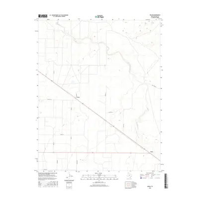
2016 Map of Bolin
USGS Topo · Published 2016About this map
Rita Blanca Cr meanders across this High Plains landscape, carving subtle drainage patterns through the ranchlands of Dallam County. This 2016 survey highlights a sparse settlement pattern characteristic of the Texas Panhandle, anchored by the localities of Ware and Bolin. The map reveals a highly structured grid of section-line roads, many bearing family names that serve as vital clues for genealogists and local historians, including Pollard Rd, Ware Rd, and Brorman Rd. A diagonal highway route cuts across this rectilinear system, connecting the small hubs of Ware and Bolin while providing a central corridor through the surrounding open range. The landscape is defined by its wide-open character, with the channel of Rita Blanca Cr serving as the primary natural landmark amidst a network of rural lanes like Mustang Ln and Hoss Carter Rd.
Find a feature on this map
15 named features on this map. Tap any name to fly to it.
Don’t see what you’re looking for? This feature index may not catch every label — zoom into the map to look around manually.
Map Details
Editions of this 2016 Bolin Map
This is the sole edition of this map. No revisions or reprints were ever made.
Other maps of this area

1954 · Dalhart
USGS Topo · 1:250,000

1958 · Dalhart
USGS Topo · 1:250,000

1962 · Dalhart
USGS Topo · 1:250,000

1973 · Wharton Ranch
USGS Topo · 1:24,000

1973 · Tovrea Ranch
USGS Topo · 1:24,000

1973 · Perico
USGS Topo · 1:24,000

1973 · Canyon School
USGS Topo · 1:24,000

1973 · Bolin NE
USGS Topo · 1:24,000

1973 · Bolin
USGS Topo · 1:24,000
1973 · Wells Ranch
USGS Topo · 1:24,000