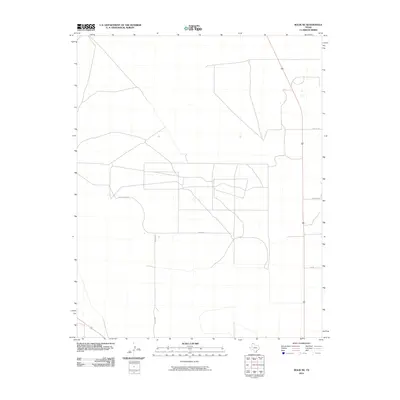
2010 Map of Bolin NE
USGS Topo · Published 2010About this map
Mackey Rd anchors a network of rural thoroughfares in this High Plains landscape, reflecting the organized, rectangular land divisions characteristic of Dallam County. This 2010 survey records the layout of local travel ways such as Hoss Carter Ln and Beach Ln, which serve the expansive agricultural operations of the Texas Panhandle. The placement of Porter Ln and Orchard Ln indicates a pattern of large-scale farming and ranching parcels common to this region's modern agrarian economy. The absence of dense urban development highlights the area's role as a dedicated agricultural corridor, where long-standing family-named roads like 5m Ln facilitate the movement of equipment and cattle across the open terrain.
Find a feature on this map
6 named features on this map. Tap any name to fly to it.
Don’t see what you’re looking for? This feature index may not catch every label — zoom into the map to look around manually.
Map Details
Editions of this 2010 Bolin NE Map
This is the sole edition of this map. No revisions or reprints were ever made.
Other maps of this area

1954 · Dalhart
USGS Topo · 1:250,000

1958 · Dalhart
USGS Topo · 1:250,000

1962 · Dalhart
USGS Topo · 1:250,000

1973 · Tovrea Ranch
USGS Topo · 1:24,000

1973 · Canyon School
USGS Topo · 1:24,000

1973 · Bolin NE
USGS Topo · 1:24,000

1973 · Bolin
USGS Topo · 1:24,000
1973 · Pritchard Ranch
USGS Topo · 1:24,000
1973 · Dalhart East
USGS Topo · 1:24,000
1973 · Dalhart West
USGS Topo · 1:24,000