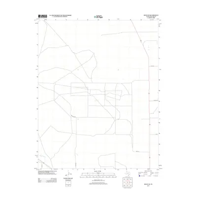
2012 Map of Bolin NE
USGS Topo · Published 2012About this map
Rita Blanca Cr winds through the southwestern corner of this landscape in Dallam County, marking one of the few natural hydrographic features in an area defined by large-scale agricultural and ranching divisions. The terrain is organized by a geometric grid of rural roads and lanes, many of which carry local family or descriptive names such as Hoss Carter Ln, Porter Ln, and Beach Ln. This network of transit lines, including Dairy Rd and Mackey Rd, illustrates the modernization of Texas Panhandle land management in the early 21st century. The sparse distribution of named features emphasizes the open, low-density character of this region, where infrastructure is primarily focused on connecting distant homesteads and agricultural operations along corridors like Orchard Ln and 5m Ln.
Find a feature on this map
8 named features on this map. Tap any name to fly to it.
Don’t see what you’re looking for? This feature index may not catch every label — zoom into the map to look around manually.
Map Details
Editions of this 2012 Bolin NE Map
This is the sole edition of this map. No revisions or reprints were ever made.
Other maps of this area

1954 · Dalhart
USGS Topo · 1:250,000

1958 · Dalhart
USGS Topo · 1:250,000

1962 · Dalhart
USGS Topo · 1:250,000

1973 · Tovrea Ranch
USGS Topo · 1:24,000

1973 · Canyon School
USGS Topo · 1:24,000

1973 · Bolin NE
USGS Topo · 1:24,000

1973 · Bolin
USGS Topo · 1:24,000
1973 · Pritchard Ranch
USGS Topo · 1:24,000
1973 · Dalhart East
USGS Topo · 1:24,000
1973 · Dalhart West
USGS Topo · 1:24,000