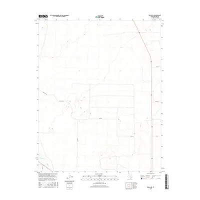
2016 Map of Bolin NE
USGS Topo · Published 2016About this map
Rita Blanca Cr cuts through the southwestern corner of this Dallam County landscape, providing a rare water feature in an otherwise dry, high-plains environment. The terrain is defined by its sprawling agricultural and ranching layout, where a network of straight-line local roads facilitates movement across the open country. These routes often bear the names of local residents or families, such as Hoss Carter Rd, Porter Ln, and Mackey Rd, reflecting the individual ownership and localized nature of the region's land use. The presence of Beach Ln and Orchard Ln suggests a history of planned development or specific land management practices that have shaped this portion of the Texas Panhandle. This survey provides a clear look at the sparsely populated rural infrastructure that supports the area's ranching economy.
Find a feature on this map
9 named features on this map. Tap any name to fly to it.
Don’t see what you’re looking for? This feature index may not catch every label — zoom into the map to look around manually.
Map Details
Editions of this 2016 Bolin NE Map
This is the sole edition of this map. No revisions or reprints were ever made.
Other maps of this area

1954 · Dalhart
USGS Topo · 1:250,000

1958 · Dalhart
USGS Topo · 1:250,000

1962 · Dalhart
USGS Topo · 1:250,000

1973 · Tovrea Ranch
USGS Topo · 1:24,000

1973 · Canyon School
USGS Topo · 1:24,000

1973 · Bolin NE
USGS Topo · 1:24,000

1973 · Bolin
USGS Topo · 1:24,000
1973 · Pritchard Ranch
USGS Topo · 1:24,000
1973 · Dalhart East
USGS Topo · 1:24,000
1973 · Dalhart West
USGS Topo · 1:24,000