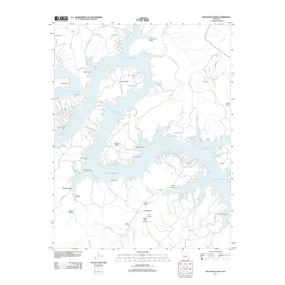
2011 Map of Bollinger Creek
USGS Topo · Published 2011About this map
Lake of the Ozarks dominates this Camden County landscape, its winding, dendritic arms creating a complex network of points and coves including Wilson Bend, Coffman Bend, and Thornsberry Point. The intricate shoreline has shaped local development, as seen in the cluster of roads near Ivy Bend and the presence of the Ivy Bend Landing Strip. Higher elevations above the water feature numerous hollows, such as Wildcat Hollow and Wells Branch Hollow, alongside small settlements like Dodds. For those researching local history, the map provides precise locations for several burial sites tucked away in the terrain, including Parish Cemetery, Carver Cemetery, and Woolery Cemetery. This topography illustrates the intersection of recreation-based lakeside living with the older rural roots of the Missouri hills.
Find a feature on this map
139 named features on this map. Tap any name to fly to it.
Don’t see what you’re looking for? This feature index may not catch every label — zoom into the map to look around manually.
Map Details
Editions of this 2011 Bollinger Creek Map
This is the sole edition of this map. No revisions or reprints were ever made.
Other maps of this area

1887 · Warsaw
USGS Topo · 1:125,000

1888 · Versailles
USGS Topo · 1:125,000

1893 · Versailles
USGS Topo · 1:125,000

1894 · Warsaw
USGS Topo · 1:125,000

1904 · Gravois Mills
USGS Topo · 1:62,500

1934 · Purvis
USGS Topo · 1:24,000

1934 · Irontown Ferry
USGS Topo · 1:24,000

1934 · Green Bay Terrace
USGS Topo · 1:24,000

1935 · Gravois Mills
USGS Topo · 1:24,000

1935 · Barnumton
USGS Topo · 1:24,000