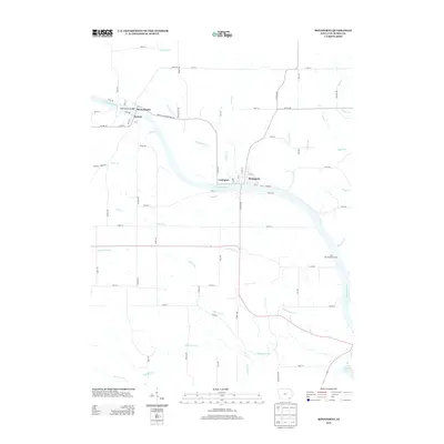
2013 Map of Bonaparte
USGS Topo · Published 2013About this map
The Des Moines River carves a deep southeastern arc through Van Buren County, anchoring a cluster of riverfront settlements established during Iowa's early decades. Bonaparte and Lexington sit on the northern bank, while the twin hamlets of Bentonsport and Vernon face each other across the water to the west, linked by the Bentonsport Bridge. This geography reflects a 19th-century reliance on river power and transport, where the narrow flats between the bluffs and the water dictated the town plans. Away from the river, the landscape transitions into a grid of county roads and agricultural plots drained by numerous tributaries like White Oak Cr and Little Indian Cr. The inclusion of the Des Moines River Access and Indian Lake illustrates the modern shift toward conservation and recreation in a region where the industrial importance of the river has evolved into a cultural and natural corridor.
Find a feature on this map
65 named features on this map. Tap any name to fly to it.
Don’t see what you’re looking for? This feature index may not catch every label — zoom into the map to look around manually.
Map Details
Editions of this 2013 Bonaparte Map
This is the sole edition of this map. No revisions or reprints were ever made.
Other maps of this area

1958 · Burlington
USGS Topo · 1:250,000

1961 · Burlington
USGS Topo · 1:250,000

1963 · Burlington
USGS Topo · 1:250,000

1968 · Anson
USGS Topo · 1:24,000

1968 · Bonaparte
USGS Topo · 1:24,000
1968 · Croton
USGS Topo · 1:24,000

1968 · Keosauqua
USGS Topo · 1:24,000

1968 · Farmington
USGS Topo · 1:24,000
1968 · Mount Sterling
USGS Topo · 1:24,000
1981 · Mount Zion
USGS Topo · 1:24,000