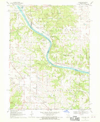
1968 Map of Croton
USGS Topo · Published 1970About this map
The Des Moines River carves a prominent path through this landscape, serving as the natural boundary between Missouri and Iowa. In the late 1960s, the region was defined by a mix of timbered uplands and river-bottom agriculture, with the Shimek State Forest preserved in the north. The area's deep history is explicitly marked by the Old Indian Treaty Boundary, which cuts across the northern terrain. Small settlements like Athens and Croton sit directly on opposite banks of the river, while Peaksville serves the southern rural interior. Transportation corridors are well-defined by the Chicago Rock Island and Pacific railroad, which parallels the river's course. Local genealogical interest is high due to the presence of several family-named burial sites including Shaffer Cem, Walker Cem, and Northrup Cem, alongside a standalone Grave in the Sweet Home township.
Find a feature on this map
32 named features on this map. Tap any name to fly to it.
Don’t see what you’re looking for? This feature index may not catch every label — zoom into the map to look around manually.
Map Details
Editions of this 1968 Croton Map
2 editions found
Other maps of this area

1903 · Kahoka
USGS Topo · 1:125,000

1949 · Wayland
USGS Topo · 1:24,000

1949 · Kahoka
USGS Topo · 1:24,000

1950 · Kahoka
USGS Topo · 1:24,000

1950 · Wayland
USGS Topo · 1:24,000

1950 · Medill
USGS Topo · 1:24,000

1951 · Medill
USGS Topo · 1:24,000

1958 · Burlington
USGS Topo · 1:250,000

1961 · Burlington
USGS Topo · 1:250,000

1963 · Burlington
USGS Topo · 1:250,000