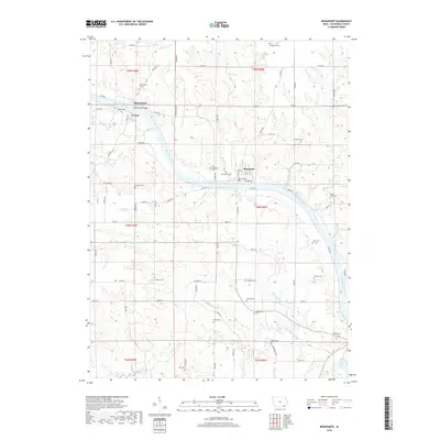
2018 Map of Bonaparte
USGS Topo · Published 2018About this map
The Des Moines River winds through the heart of Van Buren County, anchoring the historic villages of Bonaparte and Bentonsport. This 2018 survey reveals a landscape where modern road networks like Co Hwy J40 and River Rd intersect with nineteenth-century settlement patterns. The abundance of small burial grounds, such as New Lexington Cem, Vernon Cem, and Bradford Cem, offers a detailed map for genealogists tracing early families in the region. Tributaries including Bear Creek, Little Indian Cr, and Reeds Cr carve through the terrain, while Indian Lake marks the southern reaches of the quadrangle. The map captures the enduring footprint of river-based communities and the rural cemeteries that serve as a testament to the area's deep family roots.
Find a feature on this map
89 named features on this map. Tap any name to fly to it.
Don’t see what you’re looking for? This feature index may not catch every label — zoom into the map to look around manually.
Map Details
Editions of this 2018 Bonaparte Map
This is the sole edition of this map. No revisions or reprints were ever made.
Other maps of this area

1958 · Burlington
USGS Topo · 1:250,000

1961 · Burlington
USGS Topo · 1:250,000

1963 · Burlington
USGS Topo · 1:250,000

1968 · Anson
USGS Topo · 1:24,000

1968 · Bonaparte
USGS Topo · 1:24,000
1968 · Croton
USGS Topo · 1:24,000

1968 · Keosauqua
USGS Topo · 1:24,000

1968 · Farmington
USGS Topo · 1:24,000
1968 · Mount Sterling
USGS Topo · 1:24,000
1981 · Mount Zion
USGS Topo · 1:24,000