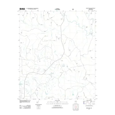
2012 Map of Bond Pond
USGS Topo · Published 2012About this map
Bluff Cr and its many tributaries, including Sandy Run and Bridge Cr, dominate this landscape north of Wiggins. This 2012 survey illustrates a region defined by its water systems and family-linked geography, where the southern reaches of the De Soto National Forest meet local homesteads. Several burial grounds, such as Taylor Cemetery and the Howard-Breland Cem, are scattered across the terrain, offering significant value for genealogists tracing South Mississippi families. The drainage patterns of Beaverdam Cr in the north and the larger Flint Creek Reservoir to the southwest reveal a low-lying environment where roads like Earl Breland Rd and Melvin Breland Rd follow the natural rises in the land. The presence of Bond Pond and the Cypress Creek Landing highlights the long-standing reliance on these waterways for both transport and local industry.
Find a feature on this map
64 named features on this map. Tap any name to fly to it.
Don’t see what you’re looking for? This feature index may not catch every label — zoom into the map to look around manually.
Map Details
Editions of this 2012 Bond Pond Map
This is the sole edition of this map. No revisions or reprints were ever made.
Other maps of this area

1947 · Beaumont
USGS Topo · 1:62,500

1947 · Wiggins
USGS Topo · 1:62,500

1947 · New Augusta
USGS Topo · 1:62,500

1947 · Benndale
USGS Topo · 1:62,500

1949 · Wiggins
USGS Topo · 1:62,500

1949 · Beaumont
USGS Topo · 1:62,500

1949 · New Augusta
USGS Topo · 1:62,500

1949 · Benndale
USGS Topo · 1:62,500

1953 · Hattiesburg
USGS Topo · 1:250,000

1953 · Mobile
USGS Topo · 1:250,000