1983 Map of Bond Pond
USGS Topo · Published 1983About this map
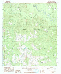
De Soto National Forest covers the majority of this landscape in south Mississippi, where the headwaters of the Pascagoula River system carve through the terrain. The presence of the St Stephens Base Line at the northern edge marks a critical surveying boundary for the region. Significant water features like Black Creek and the Flint Creek Reservoir dominate the hydrology, while the Flint Creek Water Park and Janice Landing Recreation Site indicate the area's transition toward managed recreational use by the early 1980s.
Find a feature on this map
37 named features on this map. Tap any name to fly to it.
Don’t see what you’re looking for? This feature index may not catch every label — zoom into the map to look around manually.
Map Details
Editions of this 1983 Bond Pond Map
This is the sole edition of this map. No revisions or reprints were ever made.
Other maps of this area

1947 · Beaumont
USGS Topo · 1:62,500

1947 · Wiggins
USGS Topo · 1:62,500

1947 · New Augusta
USGS Topo · 1:62,500

1947 · Benndale
USGS Topo · 1:62,500

1949 · Wiggins
USGS Topo · 1:62,500

1949 · Beaumont
USGS Topo · 1:62,500

1949 · New Augusta
USGS Topo · 1:62,500

1949 · Benndale
USGS Topo · 1:62,500

1953 · Hattiesburg
USGS Topo · 1:250,000

1953 · Mobile
USGS Topo · 1:250,000