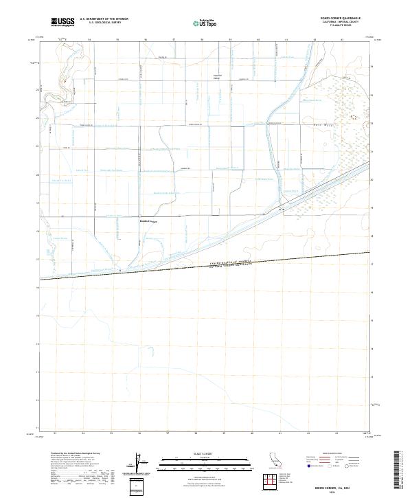
2021 Map of Bonds Corner
USGS Topo · Published 2021About this map
The Imperial Valley and East Mesa transition is defined by an intricate network of irrigation and drainage infrastructure situated along the international border between the United States and Mexico. This landscape centers on Bonds Corner, where a grid of rural routes like Verde School Rd and Bonds Corner Rd intersects a dense system of hydraulic engineering. The map reveals the critical importance of water management in this arid region, tracing the path of the massive All American Canal as it skirts the southern boundary alongside the Alamo River. Local agricultural life is supported by a complex hierarchy of channels including the Holt Canal, Hemlock Canal, and Whitcomb Canal, as well as numerous specialized drains such as Bonds Corner Drain One and the Schenk Two Drain. This grid-like pattern of laterals and drains illustrates the high-intensity desert reclamation that transformed this portion of Imperial County.
Find a feature on this map
73 named features on this map. Tap any name to fly to it.
Don’t see what you’re looking for? This feature index may not catch every label — zoom into the map to look around manually.
Map Details
Editions of this 2021 Bonds Corner Map
This is the sole edition of this map. No revisions or reprints were ever made.
Other maps of this area

1907 · Holtville
USGS Topo · 1:125,000

1940 · Alamorio
USGS Topo · 1:62,500

1940 · Calexico
USGS Topo · 1:62,500

1942 · El Centro
USGS Topo · 1:250,000

1943 · Calexico
USGS Topo · 1:62,500

1945 · Alamorio
USGS Topo · 1:62,500
1953 · Calexico
USGS Topo · 1:50,000

1954 · El Centro
USGS Topo · 1:250,000

1954 · Midway Well NW
USGS Topo · 1:24,000
1954 · Glamis SW
USGS Topo · 1:24,000