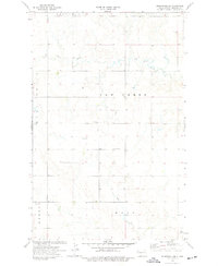
1974 Map of Bonetraill SE
USGS Topo · Published 1977About this map
Cow Creek and its seasonal tributaries carve a winding path through the high plains of Williams County in the mid-1970s. This survey records a sparsely populated landscape defined by ranching and resource extraction, where life centers around the higher ground of Bull Butte and Hebron. Local history is anchored at the St George Cem and Cow Creek Cem, which serve as quiet markers of the early families who settled this open country. The economy of the era is evidenced by several Gravel Pit sites and a Well, reflecting the region's reliance on both the land's surface materials and its subsurface resources. In the southeastern corner, a solitary Radio Tower stands near Sand Creek, representing the communication infrastructure connecting this remote corner of North Dakota to the wider world.
Find a feature on this map
13 named features on this map. Tap any name to fly to it.
Don’t see what you’re looking for? This feature index may not catch every label — zoom into the map to look around manually.
Map Details
Editions of this 1974 Bonetraill SE Map
This is the sole edition of this map. No revisions or reprints were ever made.
Other maps of this area

1953 · Williston
USGS Topo · 1:250,000

1957 · Williston
USGS Topo · 1:250,000

1959 · Williston West
USGS Topo · 1:24,000

1974 · Blacktail Lake
USGS Topo · 1:24,000

1974 · Bonetraill
USGS Topo · 1:24,000

1974 · Otter Tail Creek
USGS Topo · 1:24,000

1974 · West Bonetraill
USGS Topo · 1:24,000

1974 · Bonetraill SW
USGS Topo · 1:24,000

1974 · Trenton NE
USGS Topo · 1:24,000
1974 · Trenton NW
USGS Topo · 1:24,000