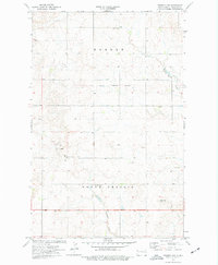
1974 Map of Trenton NW
USGS Topo · Published 1977About this map
Round Prairie Ch and the neighboring Round Prairie Sch serve as the community heart of this Williams County landscape during the mid-1970s. The map reveals a rural transition where traditional prairie life meets industrial activity, evidenced by the presence of an Oil Well and various Gravel Pits scattered across the township lines. A significant historical marker, the Old Military Reservation Boundary, cuts across the center of the sheet, delineating former federal land use that shaped the local survey patterns. To the north, the Pioneer Sch stands near the headwaters of Painted Woods Creek, while the southern reaches are drained by Eightmile Creek. Modern infrastructure is represented by the Radio Tower (KXMD-TV), illustrating the era's communication network across the rolling terrain of Hebron and Round Prairie.
Find a feature on this map
14 named features on this map. Tap any name to fly to it.
Don’t see what you’re looking for? This feature index may not catch every label — zoom into the map to look around manually.
Map Details
Editions of this 1974 Trenton NW Map
This is the sole edition of this map. No revisions or reprints were ever made.
Other maps of this area

1953 · Williston
USGS Topo · 1:250,000

1954 · Wolf Point
USGS Topo · 1:250,000

1957 · Williston
USGS Topo · 1:250,000

1958 · Wolf Point
USGS Topo · 1:250,000

1968 · Trenton SW
USGS Topo · 1:24,000

1968 · Bainville SE
USGS Topo · 1:24,000

1969 · Trenton
USGS Topo · 1:24,000

1974 · Red Bank Creek
USGS Topo · 1:24,000

1974 · Bonetraill SW
USGS Topo · 1:24,000

1974 · Trenton NE
USGS Topo · 1:24,000