
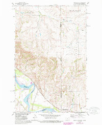
1968 Map of Bainville SE
USGS Topo · Published 1971About this map
The Missouri River forms the southern lifeline of this landscape along the Montana and North Dakota border, where it meets a complex network of drainage ravines including Snowden Coulee and Garden Coulee. In the late 1960s, this area was a critical junction of transportation and preservation, notably featuring the Fort Union Trading Post National Historic Site along the riverbank. The rail infrastructure of the Burlington Northern and Great Northern lines underscores the region's importance as a transit corridor. Higher ground is defined by the expansive Round Prairie and the evocative terrain of Hard Scrabble to the east. Genealogists and local historians will find value in the precise locations of the Mondak Cem and Westview Cem, while the small settlement at Snowden and the nearby Stiehl Landing Strip provide evidence of rural aviation and community life in the Missouri River Basin.
Find a feature on this map
23 named features on this map. Tap any name to fly to it.
Don’t see what you’re looking for? This feature index may not catch every label — zoom into the map to look around manually.
Map Details
Editions of this 1968 Bainville SE Map
2 editions found
Other maps of this area

1909 · Glendive
USGS Topo · 1:250,000

1953 · Williston
USGS Topo · 1:250,000

1953 · Watford City
USGS Topo · 1:250,000

1954 · Glendive
USGS Topo · 1:250,000

1954 · Wolf Point
USGS Topo · 1:250,000

1957 · Glendive
USGS Topo · 1:250,000

1957 · Williston
USGS Topo · 1:250,000

1957 · Watford City
USGS Topo · 1:250,000

1958 · Wolf Point
USGS Topo · 1:250,000

1958 · Glendive
USGS Topo · 1:250,000