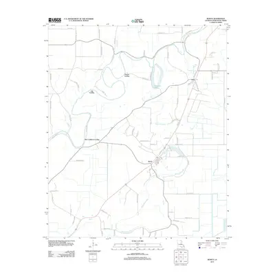
2012 Map of Bonita
USGS Topo · Published 2012About this map
Bonita serves as the central hub of this Morehouse Parish landscape, situated where the lowlands meet a network of intricate waterways. The geography is defined by the winding course of Bayou Bartholomew and the elongated reaches of Bayou Bonne Idee, which together dictate the drainage and settlement patterns of the region. The map reveals a history of river-dependent commerce through multiple designated landings, including Haynes Landing, Oak Landing, and New Landgrove Landing, suggesting a long-standing relationship with the bayous for transport and trade. Inland, the area is crisscrossed by a dense grid of local routes and trails, such as Chitlin Trl and Oscar Franklin Trl, reflecting the agricultural and timber-related infrastructure common to northern Louisiana. Near the northern boundary, Horseshoe Lake remains a prominent landmark within the bend of the bayou, while the Jones Po area marks an established community node near the eastern edge.
Find a feature on this map
76 named features on this map. Tap any name to fly to it.
Don’t see what you’re looking for? This feature index may not catch every label — zoom into the map to look around manually.
Map Details
Editions of this 2012 Bonita Map
This is the sole edition of this map. No revisions or reprints were ever made.
Other maps of this area

1935 · Wilmot
USGS Topo · 1:62,500

1935 · Naff
USGS Topo · 1:62,500

1935 · Bonita
USGS Topo · 1:62,500

1953 · Greenwood
USGS Topo · 1:250,000

1955 · Jackson
USGS Topo · 1:250,000

1956 · Greenwood
USGS Topo · 1:250,000

1956 · Bastrop
USGS Topo · 1:62,500

1958 · Bonita
USGS Topo · 1:62,500

1960 · Wilmot
USGS Topo · 1:62,500
1960 · Wilmot
USGS Topo · 1:24,000