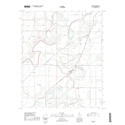
2018 Map of Bonita
USGS Topo · Published 2018About this map
Bonita and the northern settlement of Jones anchor this portion of Morehouse Parish, characterized by the winding hydrography of the Mississippi Alluvial Valley. The landscape is defined by the complex, serpentine paths of Bayou Bartholomew and Bayou Bonne Idee, which create a network of oxbows and wetlands including Horseshoe Lake. These waterways have historically dictated the agricultural and settlement patterns of the region, visible in the way modern roads like the Shackelford Loop and Jones Cutoff Rd negotiate the low-lying terrain.
Find a feature on this map
65 named features on this map. Tap any name to fly to it.
Don’t see what you’re looking for? This feature index may not catch every label — zoom into the map to look around manually.
Map Details
Editions of this 2018 Bonita Map
This is the sole edition of this map. No revisions or reprints were ever made.
Other maps of this area

1935 · Wilmot
USGS Topo · 1:62,500

1935 · Naff
USGS Topo · 1:62,500

1935 · Bonita
USGS Topo · 1:62,500

1953 · Greenwood
USGS Topo · 1:250,000

1955 · Jackson
USGS Topo · 1:250,000

1956 · Greenwood
USGS Topo · 1:250,000

1956 · Bastrop
USGS Topo · 1:62,500

1958 · Bonita
USGS Topo · 1:62,500

1960 · Wilmot
USGS Topo · 1:62,500
1960 · Wilmot
USGS Topo · 1:24,000