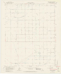
1963 Map of Bonita Ranch
USGS Topo · Published 1964About this map
Agricultural development in Madera County centers on the Fresno River as it flows through this San Joaquin Valley landscape in the early 1960s. The map illustrates a highly organized grid of roads and irrigation infrastructure, including the Airport Ditch and the Gravelly Ford Canal, which support the namesake Bonita Ranch and El Peco Ranch. These large-scale ranching operations are interspersed with community landmarks like the New Hope Cem and the Howard Sch, signaling the established social fabric of the rural area during this era.
Find a feature on this map
40 named features on this map. Tap any name to fly to it.
Don’t see what you’re looking for? This feature index may not catch every label — zoom into the map to look around manually.
Map Details
Editions of this 1963 Bonita Ranch Map
4 editions found
Other maps of this area

1916 · Berenda
USGS Topo · 1:31,680

1918 · Chowchilla
USGS Topo · 1:31,680

1918 · Berenda
USGS Topo · 1:31,680

1920 · Kismet
USGS Topo · 1:31,680

1920 · Bonita Ranch
USGS Topo · 1:31,680

1921 · Mendota
USGS Topo · 1:31,680

1921 · Bonita Ranch
USGS Topo · 1:31,680

1922 · Kentucky Well
USGS Topo · 1:31,680

1922 · Madera
USGS Topo · 1:31,680

1923 · Biola
USGS Topo · 1:31,680