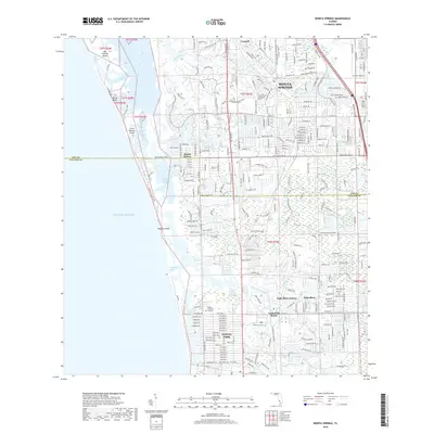
2018 Map of Bonita Springs
USGS Topo · Published 2018About this map
The Imperial River and Cocohatchee River systems dominate this coastal landscape at the boundary of Lee County and Collier County. In this 2018 survey, the intricate network of canals and residential developments defines the geography of Bonita Springs and Naples Park. The map documents the dense suburban growth between the Gulf of Mexico and the Seaboard Coast Line corridor, showing how interior waterways like Spring Creek and Leitner Creek have been integrated into local neighborhoods.
Find a feature on this map
280 named features on this map. Tap any name to fly to it.
Don’t see what you’re looking for? This feature index may not catch every label — zoom into the map to look around manually.
Map Details
Editions of this 2018 Bonita Springs Map
This is the sole edition of this map. No revisions or reprints were ever made.
Other maps of this area

1956 · West Palm Beach
USGS Topo · 1:250,000

1957 · West Palm Beach
USGS Topo · 1:250,000

1958 · West Palm Beach
USGS Topo · 1:250,000

1958 · Bonita Springs
USGS Topo · 1:24,000

1958 · Corkscrew NW
USGS Topo · 1:24,000

1958 · Estero
USGS Topo · 1:24,000

1958 · Belle Meade NW
USGS Topo · 1:24,000

1958 · Corkscrew SW
USGS Topo · 1:24,000
1958 · Fort Myers Beach
USGS Topo · 1:24,000

1958 · Naples North
USGS Topo · 1:24,000