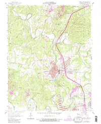
1958 Map of Bonne Terre
USGS Topo · Published 1982About this map
Industrial history and civic development define Bonne Terre, a core community in the Missouri Lead Belt as it stood during the mid-20th century. The town is marked by its proximity to mineral extraction, with a prominent Mine Dump and the Lead Belt Tech Sch reflecting the local economy. The Missouri Pacific railroad winds through the landscape, connecting the main settlement to East Bonne Terre and Hoffman Junction. Beyond the urban center, the terrain is carved by the Big River and its numerous tributaries, including Coonville Creek and Terre Bleue Creek. For genealogists, the map is a dense record of family and community burial sites, ranging from the large St Francois Cemetery to more specialized locations like the Smallpox Cem and several smaller family-named plots such as Appleberry Cem and Settle Cem. Further south, the settlements of Desloge and Cantwell appear near the river’s bend, illustrating the linear growth of the mining district.
Find a feature on this map
44 named features on this map. Tap any name to fly to it.
Don’t see what you’re looking for? This feature index may not catch every label — zoom into the map to look around manually.
Map Details
Editions of this 1958 Bonne Terre Map
4 editions found
Other maps of this area

1901 · De Soto
USGS Topo · 1:125,000

1904 · Farmington
USGS Topo · 1:62,500

1905 · Bonneterre
USGS Topo · 1:62,500

1906 · Farmington
USGS Topo · 1:62,500

1915 · Crystal City
USGS Topo · 1:62,500

1931 · De Soto SE
USGS Topo · 1:24,000

1937 · Tiff
USGS Topo · 1:24,000

1939 · Tiff
USGS Topo · 1:24,000

1949 · Saint Louis
USGS Topo · 1:250,000

1949 · Rolla
USGS Topo · 1:250,000