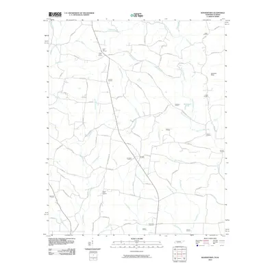
2010 Map of Bonnertown
USGS Topo · Published 2010About this map
Bird Mill and the Five Point Post Office anchor this rural landscape along the Tennessee-Alabama border, where the headwaters of Second Creek and West Fork Sugar Creek divide the terrain. The map reveals a dense network of family-named cemeteries and landmarks, reflecting generations of settlement in this borderland. Notable sites like Union Hill Cemetery and Bonnertown Cemetery are connected by a web of local routes including Bonnertown Rd and Five Points Rd. The topography is defined by distinctive features such as Steadman Ridge and the Richardson Ponds, while numerous springs like Farr Spring and Powell Spring suggest the importance of natural water sources to the local homesteads and agricultural operations of the early 21st century.
Find a feature on this map
93 named features on this map. Tap any name to fly to it.
Don’t see what you’re looking for? This feature index may not catch every label — zoom into the map to look around manually.
Map Details
Editions of this 2010 Bonnertown Map
This is the sole edition of this map. No revisions or reprints were ever made.
Other maps of this area

1914 · Rogersville
USGS Topo · 1:48,000

1916 · Rogersville
USGS Topo · 1:62,500

1936 · Union Hill
USGS Topo · 1:24,000

1936 · Lexington
USGS Topo · 1:24,000

1936 · Lawrenceburg
USGS Topo · 1:24,000

1936 · Long Branch
USGS Topo · 1:24,000

1936 · Loretto
USGS Topo · 1:24,000

1936 · Bodenham
USGS Topo · 1:24,000
1936 · Center Hill
USGS Topo · 1:24,000

1936 · Appleton
USGS Topo · 1:24,000