
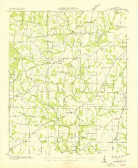
1936 Map of Bonnertown
USGS Topo · Published 1936About this map
The Tennessee-Alabama border country in 1936 is defined by a dense network of upland farms and timbered hollows, centered around the settlement of Bonnertown. This survey, compiled from aerial photographs, reveals a landscape during a period of transition, with a Tennessee Valley Authority transmission line cutting across the rural topography. The area is heavily marked by local social centers, including numerous schools and churches such as Blooming Grove Sch, Richardson Chapel Sch, and Bethel Ch. Water features like the White River Branch and West Fork Sugar Creek dictate the placement of roads and homesteads, while family names are preserved in landmarks like Bethel Cem and St Truitt Cem. The presence of small hamlets like Five Points and Upper Mockeson illustrates the high density of rural population before later 20th-century consolidation.
Find a feature on this map
55 named features on this map. Tap any name to fly to it.
Don’t see what you’re looking for? This feature index may not catch every label — zoom into the map to look around manually.
Map Details
Editions of this 1936 Bonnertown Map
This is the sole edition of this map. No revisions or reprints were ever made.
Other maps of this area

1914 · Rogersville
USGS Topo · 1:48,000

1916 · Rogersville
USGS Topo · 1:62,500

1936 · Union Hill
USGS Topo · 1:24,000

1936 · Lexington
USGS Topo · 1:24,000

1936 · Lawrenceburg
USGS Topo · 1:24,000

1936 · Long Branch
USGS Topo · 1:24,000

1936 · Loretto
USGS Topo · 1:24,000

1936 · Bodenham
USGS Topo · 1:24,000
1936 · Center Hill
USGS Topo · 1:24,000

1936 · Appleton
USGS Topo · 1:24,000