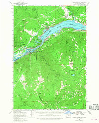
1957 Map of Bonneville Dam
USGS Topo · Published 1968About this map
Bonneville Dam dominates the landscape of the Columbia River Gorge in this late 1950s survey, showing the complex industrial and transit network bridging Oregon and Washington. The map details the Union Pacific Railroad and Portland and Spokane Pacific Railroad hugging the riverbanks, alongside the iconic Bridge of the Gods and the Tooth Rock Tunnel. While the river serves as a primary corridor for commerce and power, the surrounding heights of the Gifford Pinchot National Forest and Mount Hood National Forest are marked by recreational and administrative outposts like the Wahtum Lake Guard Sta and Indian Mtn Lookout. Local life centers on settlements such as Stevenson, Cascade Locks, and Carson, while the era's tourism is evident at St Martins Hot Springs and Moffetts Hot Springs.
Find a feature on this map
132 named features on this map. Tap any name to fly to it.
Don’t see what you’re looking for? This feature index may not catch every label — zoom into the map to look around manually.
Map Details
Editions of this 1957 Bonneville Dam Map
2 editions found

Other maps of this area

1916 · Estacada
USGS Topo · 1:125,000

1924 · Mount Hood
USGS Topo · 1:125,000

1926 · Hood River
USGS Topo · 1:125,000

1927 · Mount Hood
USGS Topo · 1:125,000

1929 · Hood River
USGS Topo · 1:125,000

1940 · Lookout Mtn
USGS Topo · 1:62,500

1948 · Vancouver
USGS Topo · 1:250,000

1950 · Vancouver
USGS Topo · 1:250,000

1950 · Vancouver
USGS Topo · 1:250,000

1953 · Lookout Mtn
USGS Topo · 1:62,500