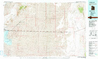
1979 Map of Bonneville Salt Flats
USGS Topo · Published 1979About this map
The Great Salt Lake Desert dominates this 1979 survey, revealing a landscape defined by extreme geography and industrial extraction. The Bonneville Salt Flats serve as a focal point, featuring the famous Bonneville International Race Track and a nearby landing strip. Along the western edge, massive salt evaporator ponds indicate the scale of mineral harvesting in the region. The map also documents the high-desert transit corridor, where the Western Pacific railroad and highway run parallel across the expansive Mud Flat, connecting isolated outposts like Salduro, Barro, Clive, and Aragonite. Cultural history is anchored by the Danger Cave State Historical Monument near the Silver Island Mountains. Much of the interior is dedicated to military use, divided between the Hill Air Force Range and the Wendover Air Force Range.
Find a feature on this map
31 named features on this map. Tap any name to fly to it.
Don’t see what you’re looking for? This feature index may not catch every label — zoom into the map to look around manually.
Map Details
Editions of this 1979 Bonneville Salt Flats Map
This is the sole edition of this map. No revisions or reprints were ever made.
Other maps of this area

1885 · Tooele Valley
USGS Topo · 1:250,000

1953 · Tooele
USGS Topo · 1:250,000

1954 · Wildcat Mtn
USGS Topo · 1:24,000

1954 · Wig Mtn NW
USGS Topo · 1:24,000

1954 · Brigham City
USGS Topo · 1:250,000

1955 · Tabbys Peak
USGS Topo · 1:24,000

1955 · Wig Mtn NE
USGS Topo · 1:24,000

1955 · Tooele
USGS Topo · 1:250,000

1955 · Wells
USGS Topo · 1:250,000

1955 · Elko
USGS Topo · 1:250,000