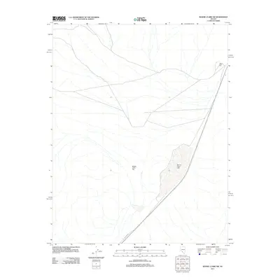
2011 Map of Bonnie Claire NW
USGS Topo · Published 2011About this map
Bonnie Claire Mill stands as a lonely industrial marker in this arid stretch of the Nevada desert. The landscape is dominated by the expansive Bonnie Claire Flat, an alluvial basin that collects into the seasonal Bonnie Claire Lake in the southern portion of the quadrangle. This 2011 survey shows a terrain shaped by sparse infrastructure, where the historical utility of the region is traced by Pole Line Rd. The alignment of roads and the presence of the mill site reflect the long-standing mineral and transport history of this remote Nye County basin, where the dry lake bed serves as a central geographic feature for local surveying and navigation.
Find a feature on this map
4 named features on this map. Tap any name to fly to it.
Don’t see what you’re looking for? This feature index may not catch every label — zoom into the map to look around manually.
Map Details
Editions of this 2011 Bonnie Claire NW Map
This is the sole edition of this map. No revisions or reprints were ever made.
Other maps of this area

1908 · Lida
USGS Topo · 1:250,000

1913 · Lida
USGS Topo · 1:250,000

1954 · Goldfield
USGS Topo · 1:250,000

1955 · Goldfield
USGS Topo · 1:250,000

1957 · Ubehebe Crater
USGS Topo · 1:62,500

1958 · Goldfield
USGS Topo · 1:250,000

1962 · Goldfield
USGS Topo · 1:250,000
1967 · Bonnie Claire SE
USGS Topo · 1:24,000
1968 · Bonnie Claire NW
USGS Topo · 1:24,000
1968 · Gold Point
USGS Topo · 1:24,000