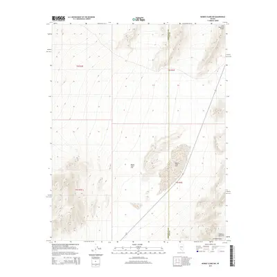
2015 Map of Bonnie Claire NW
USGS Topo · Published 2015About this map
Bonnie Claire Flat dominates this high-desert landscape on the border of Nye and Esmeralda counties. This survey illustrates the distinct geographic transition where the southern reaches of the Gold Mountain Range meet the northern edges of the Amargosa Range and Grapevine Mountains. The most prominent hydrological feature is Bonnie Claire Lake, a desert basin characteristic of the region's internal drainage patterns. The map provides a precise look at the township and range boundaries, including t8s r42e and t9s r43e, which define the property and survey lines of this arid territory during the early twenty-first century.
Find a feature on this map
10 named features on this map. Tap any name to fly to it.
Don’t see what you’re looking for? This feature index may not catch every label — zoom into the map to look around manually.
Map Details
Editions of this 2015 Bonnie Claire NW Map
This is the sole edition of this map. No revisions or reprints were ever made.
Other maps of this area

1908 · Lida
USGS Topo · 1:250,000

1913 · Lida
USGS Topo · 1:250,000

1954 · Goldfield
USGS Topo · 1:250,000

1955 · Goldfield
USGS Topo · 1:250,000

1957 · Ubehebe Crater
USGS Topo · 1:62,500

1958 · Goldfield
USGS Topo · 1:250,000

1962 · Goldfield
USGS Topo · 1:250,000
1967 · Bonnie Claire SE
USGS Topo · 1:24,000
1968 · Bonnie Claire NW
USGS Topo · 1:24,000
1968 · Gold Point
USGS Topo · 1:24,000