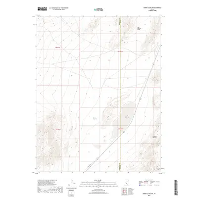
2018 Map of Bonnie Claire NW
USGS Topo · Published 2018About this map
Bonnie Claire Flat and the adjacent dry bed of Bonnie Claire Lake dominate this high-desert basin along the border of Esmeralda and Nye Counties. The landscape is defined by its expansive basins and the prominent ridgelines of the Gold Mountain Range to the north and the Grapevine Mountains and Amargosa Range to the south. Modern infrastructure is sparse, represented primarily by Pole Line Rd, which cuts diagonally across the southern portion of the quadrangle. The lack of settlements or permanent water sources underscores the arid character of the northern Amargosa Desert. Historically, the area reflects the essential transit and mineral exploration routes of the Nevada desert, where survival depended on navigation between these major mountain ranges.
Find a feature on this map
11 named features on this map. Tap any name to fly to it.
Don’t see what you’re looking for? This feature index may not catch every label — zoom into the map to look around manually.
Map Details
Editions of this 2018 Bonnie Claire NW Map
This is the sole edition of this map. No revisions or reprints were ever made.
Other maps of this area

1908 · Lida
USGS Topo · 1:250,000

1913 · Lida
USGS Topo · 1:250,000

1954 · Goldfield
USGS Topo · 1:250,000

1955 · Goldfield
USGS Topo · 1:250,000

1957 · Ubehebe Crater
USGS Topo · 1:62,500

1958 · Goldfield
USGS Topo · 1:250,000

1962 · Goldfield
USGS Topo · 1:250,000
1967 · Bonnie Claire SE
USGS Topo · 1:24,000
1968 · Bonnie Claire NW
USGS Topo · 1:24,000
1968 · Gold Point
USGS Topo · 1:24,000