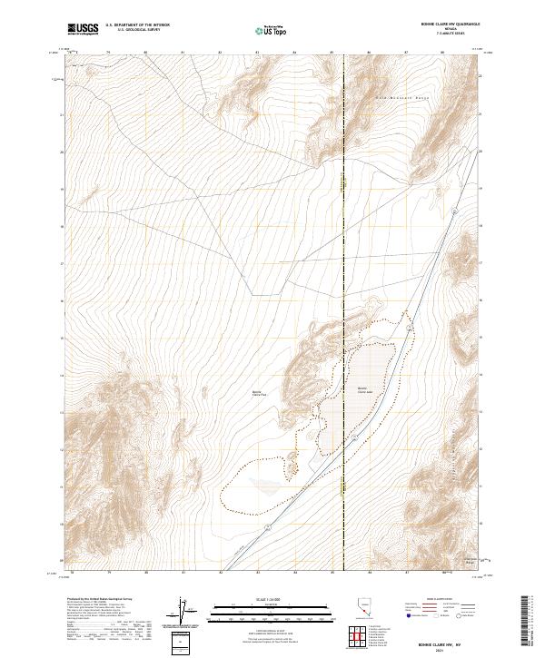
2021 Map of Bonnie Claire NW
USGS Topo · Published 2021About this map
Bonnie Claire Flat and the ephemeral Bonnie Claire Lake dominate this high-desert basin along the border of Esmeralda and Nye counties. The terrain is defined by the significant rise of the Gold Mountain Range to the north and the jagged northern edges of the Grapevine Mountains and Amargosa Range to the south. This remote landscape reflects the characteristic Great Basin topography where broad alluvial flats sit between stark, northwest-trending mountain blocks. Human presence is sparse, marked primarily by the utility corridor along Pole Line Rd and several state routes that navigate the basin floor. The map provides a clear look at the geological boundaries and drainage patterns of this arid corner of Nevada, where the desert floor transitions abruptly into steep, rocky slopes.
Find a feature on this map
11 named features on this map. Tap any name to fly to it.
Don’t see what you’re looking for? This feature index may not catch every label — zoom into the map to look around manually.
Map Details
Editions of this 2021 Bonnie Claire NW Map
This is the sole edition of this map. No revisions or reprints were ever made.
Other maps of this area

1908 · Lida
USGS Topo · 1:250,000

1913 · Lida
USGS Topo · 1:250,000

1954 · Goldfield
USGS Topo · 1:250,000

1955 · Goldfield
USGS Topo · 1:250,000

1957 · Ubehebe Crater
USGS Topo · 1:62,500

1958 · Goldfield
USGS Topo · 1:250,000

1962 · Goldfield
USGS Topo · 1:250,000
1967 · Bonnie Claire SE
USGS Topo · 1:24,000
1968 · Bonnie Claire NW
USGS Topo · 1:24,000
1968 · Gold Point
USGS Topo · 1:24,000